|
Photos and Memories of Edinburgh |
||||
|
1 |
2 |
3 |
4 |
5 |
|
Photos and Memories of Edinburgh Talk to Newhaven Community History Group 19 November 2013 |
|
4. Photos and Recollections of Granton |
|
- Recent Photos - Edinburgh at Work - Recent Photos - Streets + Harbour
|
|
GRANTON Maps and Aerial Views |
|
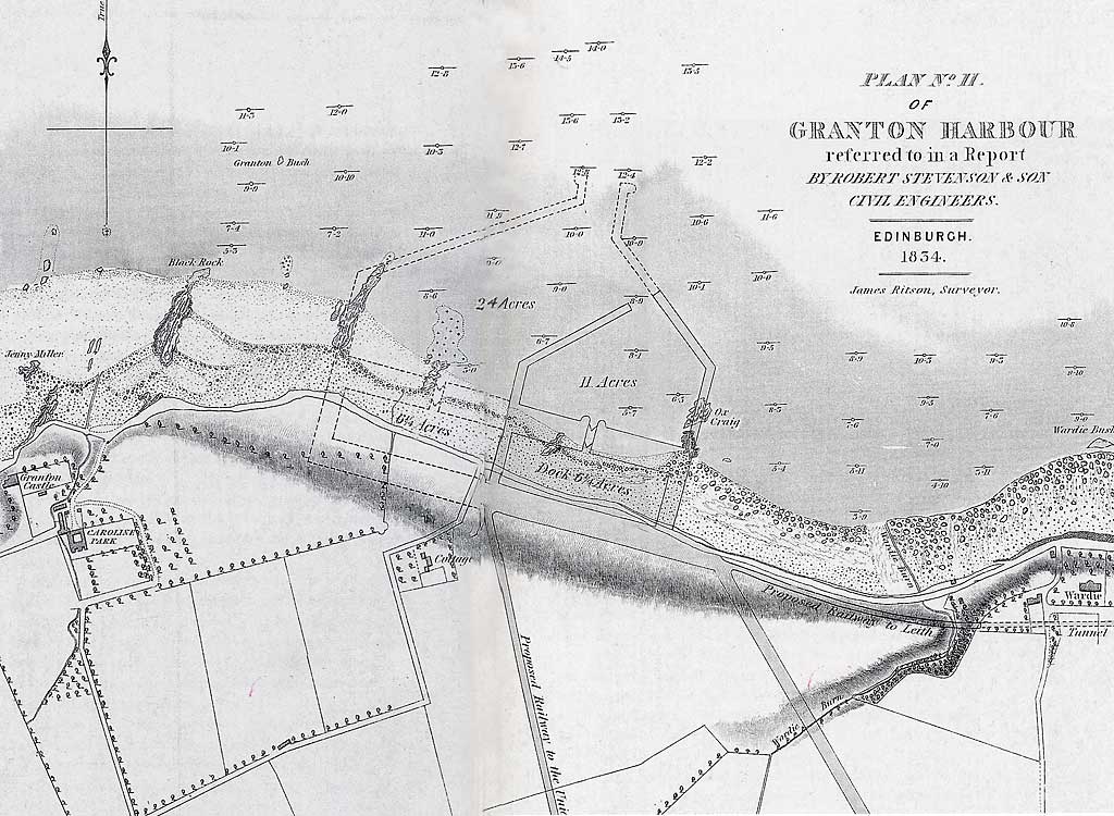
Maps and Plans Early Plans for a Harbour at Granton Several proposals were made in the early-19th century to build a harbour on the Duke of Buccleuch's land at Granton. 1. Here is a proposal from 1834, not very different in design, but considerably smaller than the harbour that was actually built a few years later. This plan also shows proposals for railways: - one to the east, through a tunnel, to Leith. - one to the south to link with the Union Canal at Fountainbridge 1834 Plan One of several proposals to build a harbour at Granton
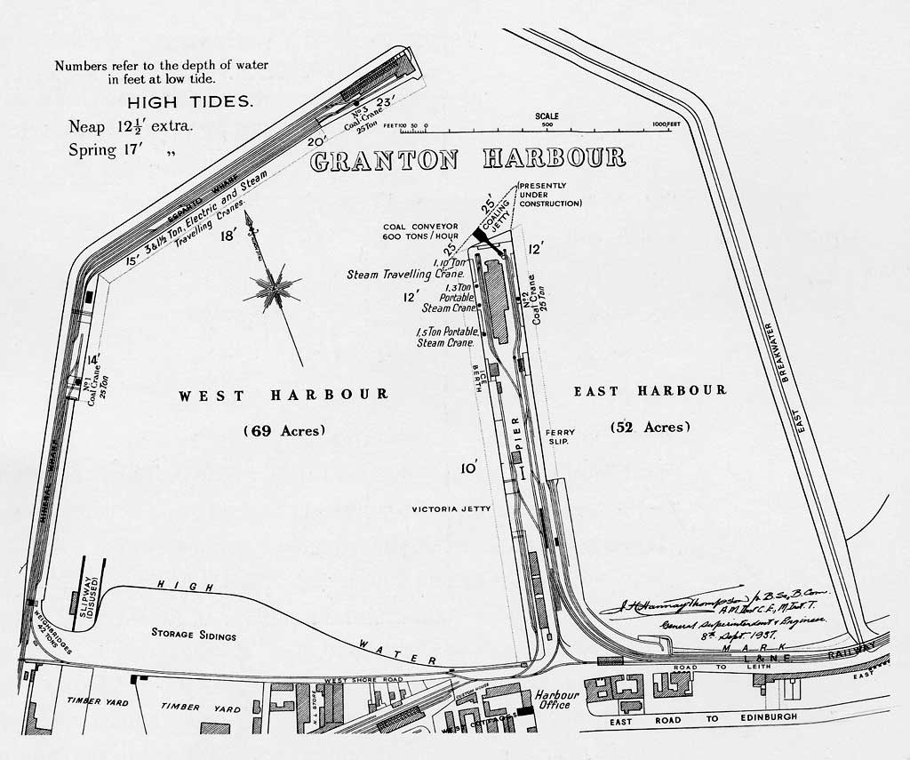
© Reproduced with acknowledgement to Buccleuch Estates and to Argyll Publishing 2. My favourite proposal was one named 'Granton Made Magnificent' (Register House Plan RHP9477) drawn up possibly around 1830. It includes the following, all marked out on the plan: - Eastern Harbour, Western Harbour, 2 inner docks, 2 outer docks, 2 further docks. - Naval Yard with Powder Store, Naval Barracks, Naval Warehouse and Naval Hospital. - Railway Station with railways to Queensferry and Cramond, Leith and Edinburgh - Canal Basin linked to the Union Canal at Fountainbridge and a Coach Stand - Markets for Flesh, Poultry, Fish, Vegetable, Fruit, Produce and Coal. - Town Hall, Bank, Counting Houses, Custom House, Consulate Offices - Post Office, Shipping Offices, Shops and Arcade. - Bonded Warehouses, Storehouses, Timber Stores, Preserving Works and Sawmill. - Grazing Parks, Stables, Horse Bazaar and Abattoir. - Bakeries, Barmeries, Breweries, and other Manufactories - Hotels, Inns, Taverns, Coffee Houses, 1st, 2nd and 3rd Class Dwelling Houses - Six Lighthouses, an Ornamental Fountain with Rude Light in the centre. _____________________________________ Granton Harbour This is a plan showing the harbour that was built at Granton. - The Act of Parliament to build Granton Harbour received Royal Assent from King William IV on April 21, 1837 - Work began on building the harbour almost immediately. - The first part of the harbour, Middle Pier, opened on Queen Victoria's Coronation Day, June 28, 1838. - Queen Victoria visited the harbour on September 1, 1842. - This plan, shows the harbour as it was in 1937, including the slipways, jetties and wharfs. - The plan also shows the position of the railway lines and gives details of the cranes in use in the harbour.
© Reproduced with acknowledgement to Buccleuch Estates and to Argyll Publishing
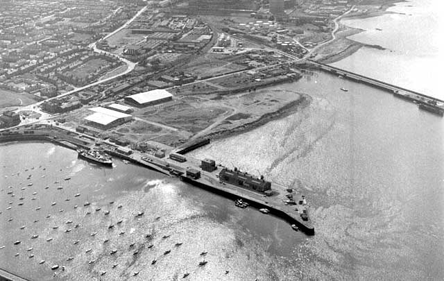
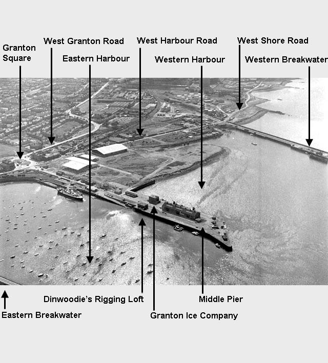
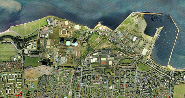
_____________________________________ Aerial Views Here are four aerial views:, looking down on: 1. Granton Harbour: early-1970s 2. Granton Harbour: early-1970s - with key 3. Granton Middle Pier: Around 1978 4. Granton Harbour, Gas Works and Housing: 2001 1. Early-1970s Aerial View
© Reproduced by courtesy of Scotsman Publications. Click here for web site details. 2. Early-1970s Aerial View with key
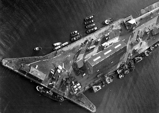
© Reproduced by courtesy of Scotsman Publications. Click here for web site details. 3.
Around Aerial View of the end of Middle Pier, Granton Harbour
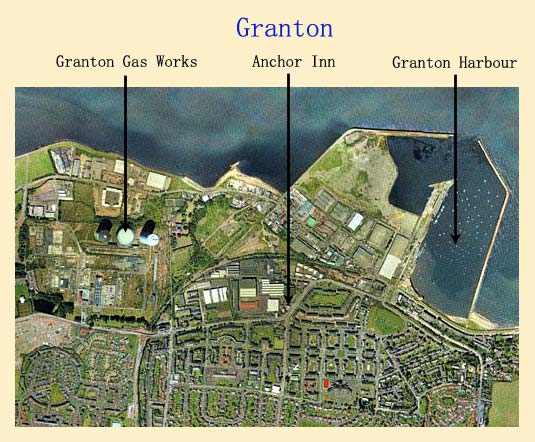
Reproduced with acknowledgement to John Dinwoodie, Granton, Edinburgh. © Robb & Campbell Harper Studios Ltd 4. 2001 Granton Gas Works, Harbour and Housing Industry vanishing - Granton Western Harbour now partly infilled
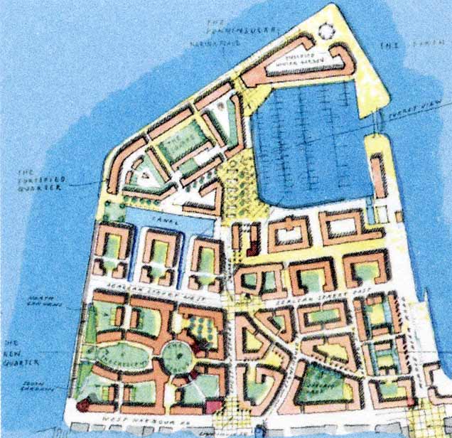
© Copyright: XYZ Digital Map Company Limited. Click here for details of web site. _____________________________________ Here we look at some recent proposed developments for Granton Waterfront: 5. Forthside Proposals (2005): Granton Harbour 6. Waterfront Proposals (2001): Granton + surrounding area 7. Waterfront Proposals (2001): Granton - boundaries 8. Waterfront Proposals (2001): Granton - landmarks Here are Forth Ports' plans for the development of Granton Harbour, published in 2005 as part of their Forthside Master Plan for the waterside at Granton and Leith. To date, very little of this land has been developed. 5. Proposals (2005) Forth Ports' Plans for development of Granton Harbour
© Forth Ports PLC See web site www.forthports.co.uk for fuller details of the Masterplan. _____________________________________ 6. Proposals (2001) Waterfront at Granton and surrounding area
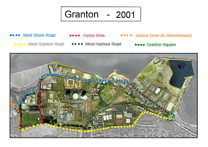
© Copyright: XYZ Digital Map Company Limited. Click here for details of web site. 7. Proposals (2001) Waterfront at Granton - Boundary Roads + Gypsy Brae
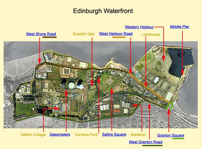
© Copyright: XYZ Digital Map Company Limited. Click here for details of web site. 8. Proposals (2001) Waterfront at Granton - Landmakrs
Since the proposals for development of the Waterfront (above) were drawn up in 2001: - 2 of the 3 gasholders at Granton Gasworks have been demolished. - a new Forthquarter Park has been created to the south of the gasholders. - new developments have been built for: - Edinburgh's Telford College - Morrison's Supermarket and Petrol Station - Scottish Gas HQ - housing, but only a small proportion of what was envisaged has been built. - a new road, Waterfront Avenue has been built between the new Scottish Gas HQ and the old lighthouse on West Harbour Road. - Waterfront Avenue has been landscaped for trams, but the proposals to run trams to Granton seem unlikely to proceed in the foreseeable future. - The slow pace of progress has been caused partly by the recession. - The owners of the Waterfront land, Forth Ports PLC have been taken over. The new owners appear to have also taken an interest in developments other than housing: in particular, further industrial developments at Leith Harbour.
|
|
GRANTON Old Engravings |
|
|
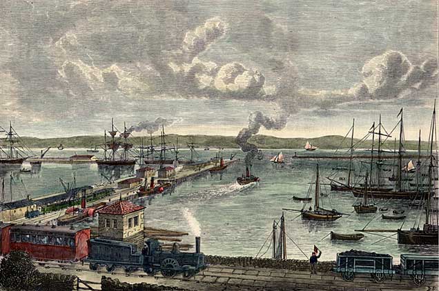
Cassel's Here is an engraving from Cassel's 'Old & New Edinburgh'. It has been hand coloured Here is one of he engravings from the book. It has been hand coloured
Published
© For permission to reproduce, please contact peter.stubbs@edinphoto.org.uk _____________________________________
Cassel's Here is an engraving from Cassel's 'Old & New Edinburgh'. It has been hand coloured.
Published
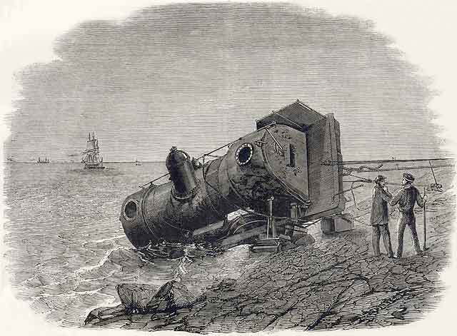
© For permission to reproduce, please contact peter.stubbs@edinphoto.org.uk _____________________________________ Illustrated London News 1860 Railway Accident on the embankment to the east of Granton Harbour
© For permission to reproduce, please contact Peter Stubbs peter.stubbs@edinphoto.org.uk
|
|
GRANTON Early Photos |
|
Granton Harbour This must be one of the earliest photos of Granton Harbour. It was taken by Thomas Vernon Begbie in the late-1850s Late-1850s
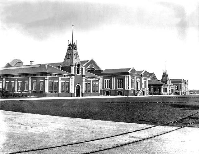
© The Cavaye Collection of Thomas Begbie Prints: City Art Centre, City of Edinburgh Museums and Galleries _____________________________________ Granton Gas Works 1903
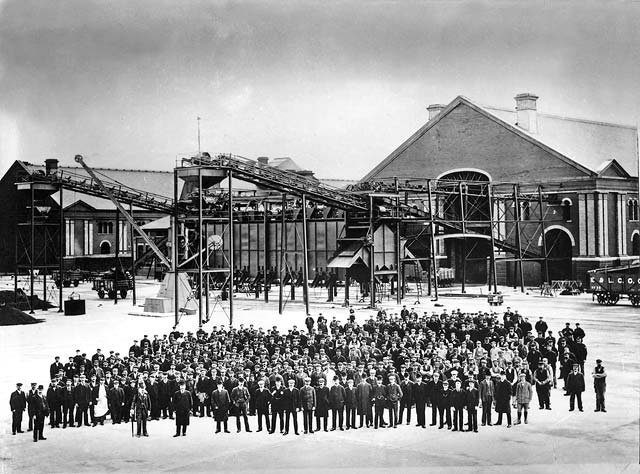
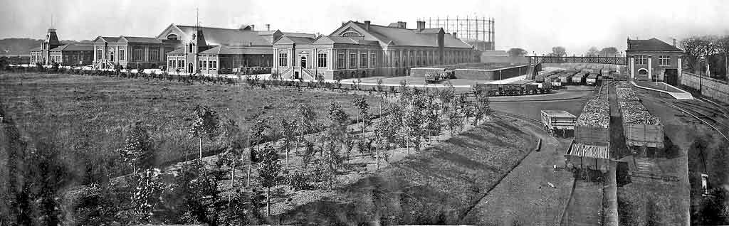
© Reproduced with acknowledgement to Proscot PR company, Leith, Edinburgh 1903
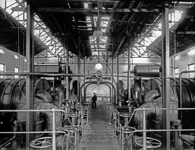
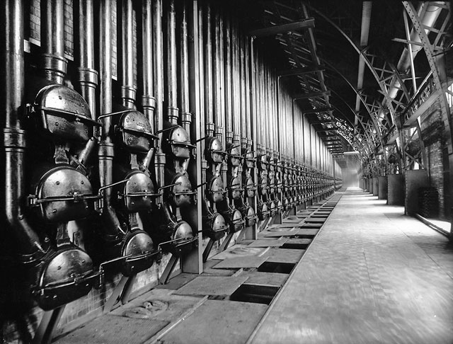
© Reproduced with acknowledgement to Gordon Rankin, Portobello, Edinburgh 1903 Granton Gas Works Retort House
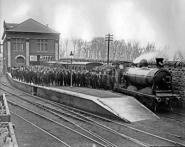
© Reproduced with acknowledgement to Gordon Rankin, Portobello, Edinburgh 1903 Granton Gas Works Station Platform
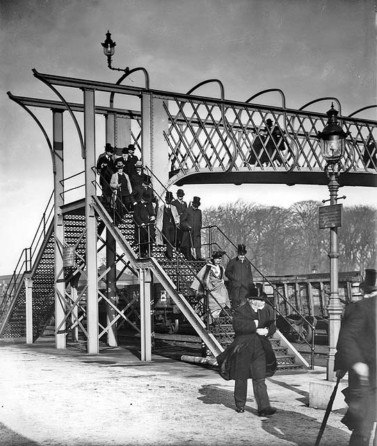
© Reproduced with acknowledgement to Proscot PR company, Leith, Edinburgh 1903 Granton Gas Works Station Footbridge
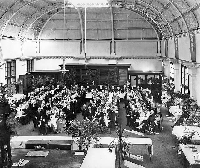
© Reproduced with acknowledgement to Proscot PR company, Leith, Edinburgh 1903 Granton Gas Works Opening Dinner
© Reproduced with acknowledgement to Proscot PR company, Leith, Edinburgh 1903
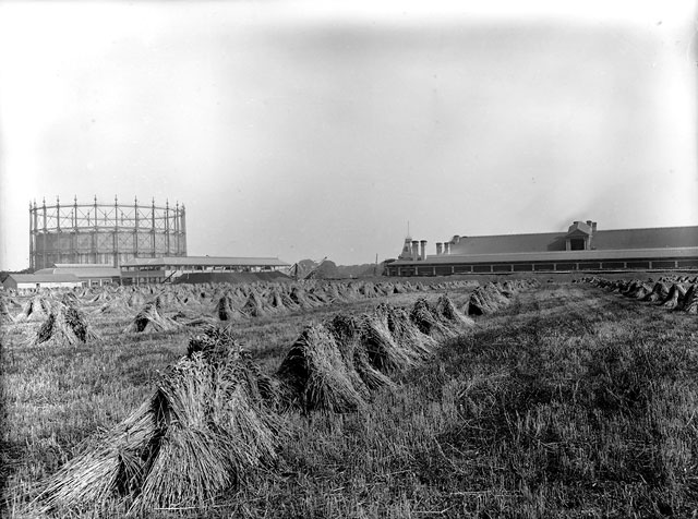
© Reproduced with acknowledgement to Proscot PR company, Leith, Edinburgh 1903 Granton Gas Works Gasholder and Hay Stacks
© Reproduced with acknowledgement to Gordon Rankin, Portobello, Edinburgh
1908
© Reproduced with acknowledgement to David Gordon, Old Town, Edinburgh 1908
© Reproduced with acknowledgement to David Gordon, Old Town, Edinburgh
|