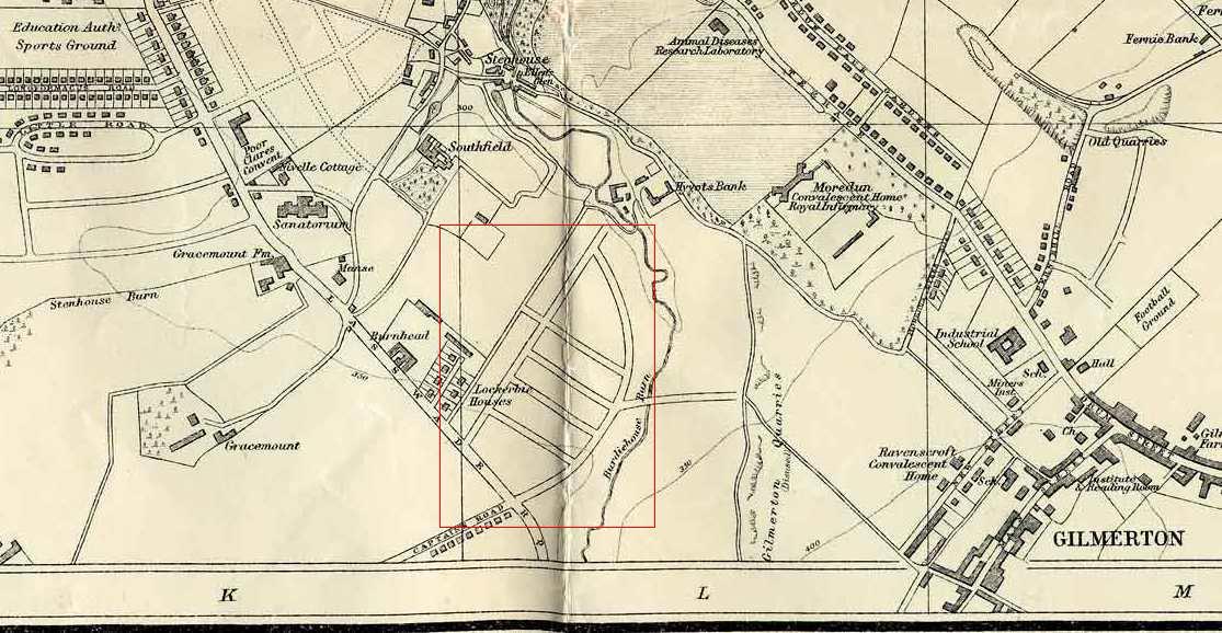
Please view this map together with the question and answer below
© For permission to reproduce please contact peter.stubbs@edinphoto.org.uk Extract from a map by Bartholemew, 1940-41
The following is an extract from the 'Gilmerton Recollections' page on the EdinPhoto web site:
|
Recollections 31 Forbes Wilson near Guildford, Surrey, England |
|
Forbes Wilson wrote Gilmerton "Having lived at 12 Gilmerton Dykes Street from 1957 to 1977, and knowing the area very well, I was wondering if any of your readers could assist me with the following question." 1940 Map - Question "In your 1940 map of the Gilmerton area, I was curious to know what are the markings outlined in the red box. They appear to be roads. Today this area is formed by Gilmerton Dykes Crescent with the Gardens, Grove and Place in the centre with the Street to the south although the aforementioned roads do not follow the same layout." Forbes Wilson, near Guildford, Surrey, England: February 17, 2010 |
|
Answer 1. to Recollections 31 Peter Stubbs Edinburgh |
|
1950s It looks to me as if what is shown in the red box on the 1940 map would be the original plan for housing on the west side of Burdiehouse Burn. But this scheme seems to have been postponed, probably due to the outbreak of the war in 1939. In fact, the housing appears not to have been built until around 1952. When it was built, the layout of the streets on the west side of Burdiehouse Burn was modified a little and streets were also built on the east side of the burn. Gilmerton Dykes Crescent was named in 1936, but it does not exactly follow the line shown on the 1940 map, so perhaps it was named then but not built until the 1950s. All other streets in this area were all named in 1952. They are: - on the west side of Burdiehouse Burn: - Gilmerton Dykes Crescent - Gilmerton Dykes Gardens - Gilmerton Dykes Grove - Gilmerton Dykes Place - on the west side of Burdiehouse Burn: - Gilmerton Dykes Avenue - Gilmerton Dykes Drive - Gilmerton Dykes Loan - Gilmerton Dykes Road - Gilmerton Dykes Terrace - Gilmerton Dykes View - on both sides of Burdiehouse Burn: - Gilmerton Dykes Street Peter Stubbs, Edinburgh: March 10, 2010 |
