|
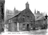
St Anthony's Lane from Giles Street to Green Jenny's Close, Leith |

© Reproduced with acknowledgement to Archie Foley, Joppa, Edinburgh
|
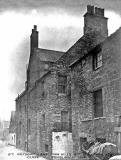
St Anthony's Close from Giles Street to Green Jenny's Close, Leith |
|
Demolition 1914 The caption says: 'St Anthony's Lane from Giles Street to Green Jenny's Close' I assume that this view looks to the north up St Anthony's Lane towards Giles Street, and that Green Jenny's Close would be the small close with the wall-mounted lamp post in the centre of this photo in front of the horse.
|
|
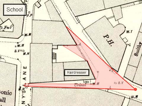
Lamp Post The wall-mounted lamp post in St Anthony's Lane on the photo at the top of this page can be seen at the lower-left point of the pink-shaded area on the map extract below. This map extract was sent to me by John Hadden to demonstrate where this photograph of a hairdresser's shop would have been taken from: Extract from 1894 Map
© Reproduced with acknowledgement to John Hadden, Edinburgh On this map: - St Anthony's Lane is the street running from top to bottom of the map, on the left. - Giles Street is the street running from top-centre to lower-right corner. - Green Jenny's Close is the narrow land running along the bottom of the map, linking St Anthony's Lane and Giles Street. |
|
Acknowledgement: Archie Foley, Joppa, Edinburgh: January 5, 2010 These are from a series of photos posted onto boards in an old album that Archie Foley acquired a few years ago. Archie believes that these are likely to be official photos that probably once belonged to Leith City Council. |