|
Around Edinburgh Edinburghshire |
|
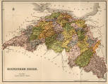
Edinburghshire - 1884 |
||
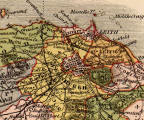
| All of Edinburghshire | Queensferry to Musselburgh |
Cramond to Portobello |

|
Around Edinburgh Edinburghshire |
|
Edinburgh Today There have been several boundary changes since the map of Edinburghshire was published in 1884. The City of Edinburgh now extends several miles from the City Centre in all directions. It is no longer part of Edinburghshire, but is surrounded by West Lothian, Mid Lothian, East Lothian and the Firth of Forth |
|
Edinburghshire The 3 views of Edinburghshire above are all taken from the same map of Edinburghshire, the second and third by zooming-in towards Edinburgh. This map was published in The Ordnance Gazetteer of Scotland in 1884. |
|
MAPS: Full index |
|
MAPS: Short Index with thumbnails |