|
Fort Fort Place to North Fort Street including A. Photo C. Map |
|
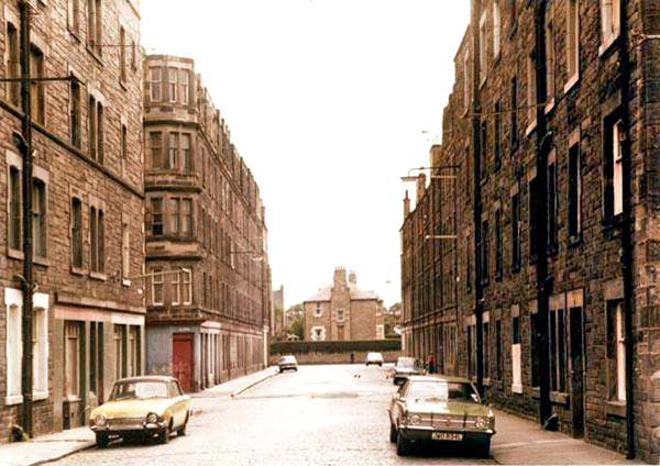
A. Fort Photo |
1978
©
John Darcy. Reproduced with
acknowledgement to John Darcy: March 16, 2010. Thank
you to Bob Moffat for
providing a copy of this photograph. and to John Stewart who runs
a
Leith web site that includes this photo.
|
B. Fort Questions + Answers |
|
Fort Place to North Fort Street |
|
Question Where was this photo taken from. When I received the photo, it was captioned 'Fort Place to North Fort Street' I've checked the old maps and found that there used to be a cross roads in Fort Place, but this photo seems to include a road only on the left. |
|
Fort Place to North Fort Street |
|
Answer 1 Thank you to Brian Swanney for providing a quick reply, supported by a photo, two google images and two old maps! Brian points out that there appears to be an optical illusion in the picture, and that the street junction is, in fact, a cross roads - but the break in the buildings on the right is not apparent from this angle (and the break in the pavement is hidden by the roof of the nearest car on the right). This view looks approximately to the SW along Fort Place from close to the Nicoll Place end of the street. The prominent house at the end of Fort Place is shown on the old maps as being Elizafield House on the corner of Dudley Bank and North Fort Street. Brian Swanney, Dunedin, Otago, New Zealand: March 24, 2010 |
|
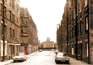
Fort Place and Hamilton Strreet |
||
|
Answer 2 Thank you to Brian Swanney for writing again. |
||
|
Brian pointed out that both these photos look towards the same cross-roads. Brian added: "Photo 1, below, shows a distinctive pale blue and red coloured corner shop or pub. Photo 2, below, shows what look like the same shop, but taken from in Hamilton Street looking across the intersection with Fort Place and into Hamilton Crescent – directly into where the “gap” ought to be in the foreshortened view in Photo 1. There is also a distinctive darker smudge on the road surface right in the middle of the crossroads on both photos."
|
||
|
Brian Swanney, Dunedin, Otago, New Zealand: April 2, 2010 |
|
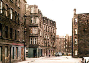
Fort Place and Hamilton Street |
|
Answer 3 Thank you to 'jrcav' who wrote |
|
Shops "There was, indeed, a cross roads in this area. The shop shown in the photo with the window boarded up was a fish and chip shop. Opposite, on the corner of Fort Place and Hamilton Crescent was Fanny Malcolm's corner shop. Looking NW along Hamilton Street The street crossing at the crossroads is Fort Place. The other shops at the bottom of Hamilton Street used to be the Co-op store which was a general merchandise, dairy and butchers. This later became Robertson's newsagent. |
|
'jrcav' : September 25, 2010 |
|
C. Fort Map |
|
Fort Place to North Fort Street |
|
Map Below is an extract from a 1925 map of Edinburgh and Leith. Elizafield House and Fort Place can be found centre-right on this map, below. |
Newhaven - 1925
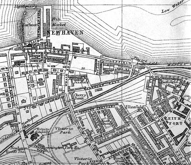
© For permission to reproduce please contact peter.stubbs@edinphoto.org.uk Extract from a map in the Post Office Directory, 1925-26