|
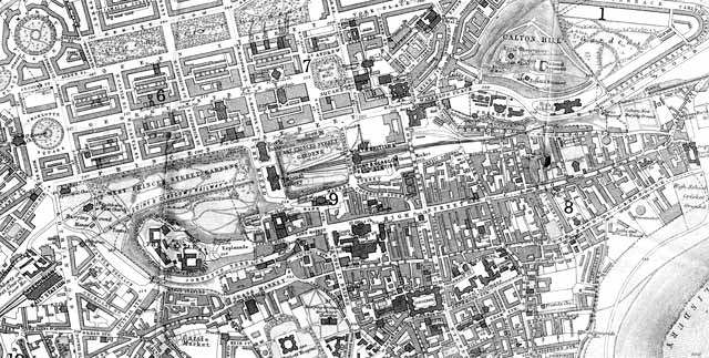
Edinburgh Castle to Calton Hill Please scroll down to see other dates and sizes of map |
Small Map
© For permission to reproduce, please contact peter.stubbs@edinphoto.org.uk
|
More Maps Larger maps show more detail, but will be slower to load |
|||
|
Edinburgh Castle to Calton Hill |
|||
|
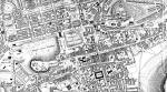
1830 |
1830 |
1830 |
|
|
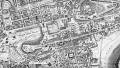
1840 |
1840 |
1840 |
|
|
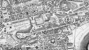
1848 |
1848 |
1848 |
|
|
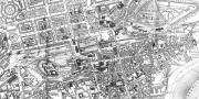
1865 |
1865 |
.
1865 |
|
|
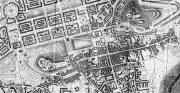
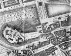
Notes It can be seen from the maps above that: - between 1830 and 1840: - George IV Bridge built. - Victoria Street built to the east of West Bow - not yet named on the map. - New West Approach built south of the castle - now named Johnston Terrace. - between 1840 and 1848: - Railway built through Princes Street Gardens. - between 1848 and 1865 (in fact, soon after 1948): - The second Gallery at the foot of the Mound built . - The Mound built . |
|||
|
Edinburgh Castle |
|||
|
zoom-in |
zoom-in |
||
|
All the images above are taken from the folding maps in Post Office Directories. These maps were engraved by C Thomson (1830), W H Lizars (1840,1848), John Bartholemew (1865). I have copied the same area of land each of these maps but some of the images are squarer than others. - The scales on the W H Lizars maps show this area to be approx. 1.25 miles x 0.75 miles. - The scale on the John Bartholemew map shows this area to be approx.1.50 miles x 0.75 miles. - The C Thomson map has no scale, but the proportions are similar to the John Bartholemew map. - The modern Ordnance Survey map shows this area to be approx.1.50 miles x 0.75 miles. |
|||


|
MAPS: Full index |
|
MAPS: Short Index with thumbnails |