|
Edinburgh New Town - Robert Kirkwood Map Second New Town 1819 |
|
|
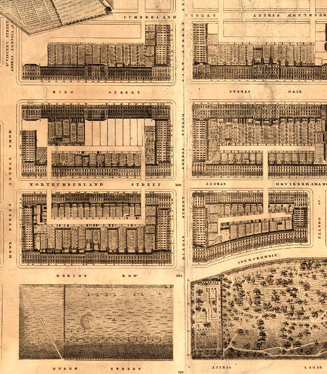
Second New Town to the north of Queen Street
© Reproduced by courtesy of the National Library of Scotland. Click here for further info, and for the NLS maps web site. |
|
|
Click here to see all other sections of this map: |
Please click an arrow
below to move to a
|
|
Click here
to see the whole map
and aerial view:
|
|
|
Second New Town |
|
|
Here is a section of the New Town, as it extended to the North from Princes Street. The road on the left leading to the north is Howe Street. It has a branch to the left to Stockbridge (not visible on this section of the map) close to the junction with King Street.. Howe Street terminates in the upper-left corner of the map at the fields of Silver Mills. It is at the top left corner of this map that St Stephen's Church was later built, to a design by Playfair. The road further east, leading to the north , to Canonmills, is Dundas Street which changed name to Pitt Street further north (but is now all named Dundas Street, to avoid confusion with Pitt Street, Leith). The section of King Street (now Great King Street) between Howe Street an Dundas Street is where Edinburgh Photographic Society's premises can be found at No 68 - above the 'G' of KING on the map above. Along the bottom of the map are sections of Queen Street Gardens These are still gardens - like several others, owned privately with access by key. |
|
|
Kirkwood Map - 1819 |