|
Edinburgh's Transport - Maps Railways Early 1900s |
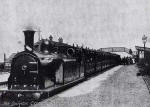
North British Railway and Caledonian Railway lines in Edinburgh
![]()
© Copyright: For permission to reproduce, please contact peter.stubbs@edinphoto.org.uk
|
Railways - 1900s The map above by W&K Johnston Ltd is not dated, but may well have been produced in the early 1900s. It is one of several maps published in TS Muir's book Edinburgh and District - An Introduction to Geography, published in 1910. The network of lines from: - North British Railway (arriving in Waverley Station from the East Coast route) - Caledonian Railway (arriving in Princes Street Station from the West Coast Route. Both railways ran lines from the centre of Edinburgh to Granton and to Leith. Several stations are shown and named on the map above, more easily seen by zooming in to one half of the map. |
|
Old Map and Engraving This book also includes an attractive small map of Edinburgh in the 18th century and small engraving of Edinburgh from St Anthony's Chapel in Queen's Park. |
|
TRANSPORT |
|||||||
| Full Index |
Bus Tickets |
Railway Tickets |
|||||