|
Sighthill and Calder Map 1955
This map extract was added to
the EdinPhoto web site |
The prefab housing was in the Calder streets at the bottom of this map.
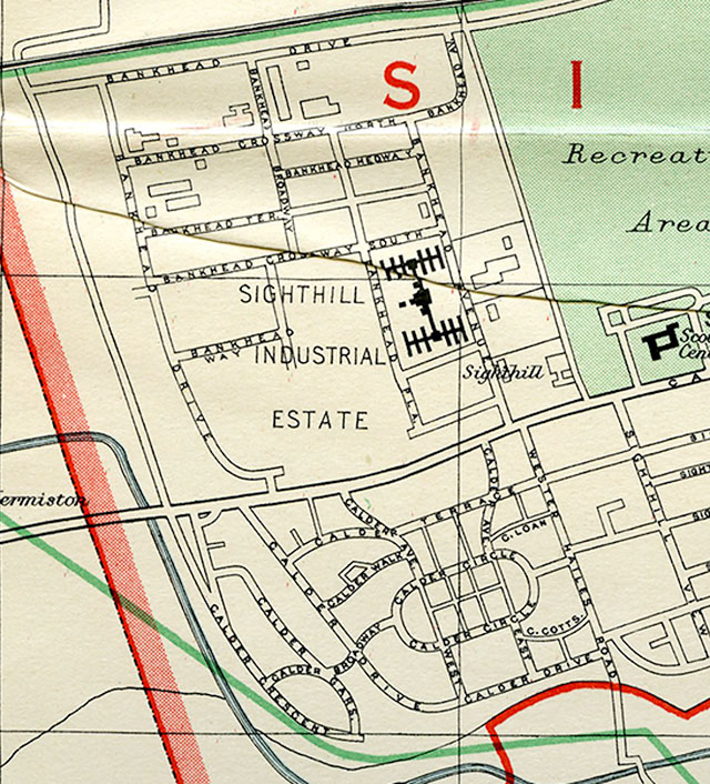
© For permission to reproduce please contact peter.stubbs@edinphoto.org.uk Extract from a map by Bartholemew, 1955-56
|
Comments 1. Peter Stubbs Edinburgh |
||||||||||||||||||||||||||||||||||||
|
I added this extract from a 1955 map to the EdinPhoto web site in response to a question from Chris Smith who added: "Do you have any maps of the Sighthill area of Edinburgh from around the 1950's? I was born in a prefab in Calder Walk in 1960 and would like to know where this road was." Chris Smith, Turnhouse, Edinburgh: March 17, 2013 |
||||||||||||||||||||||||||||||||||||
|
Streets In fact, the lay-out of the Calder estate is now quite different now to how it was laid out in the 1940s and 1950s when it was one of the areas of Edinburgh that had 'prefab houses' to ease the housing shortage following World War II. These are the 'Calder' street names on the estate between Calder Road, Wester Hailes Road and the Union Canal at Sighthill, close to the City of Edinburgh Bypass:
|
||||||||||||||||||||||||||||||||||||
|
Comments 2. Stewart Fizia |
||||||||||||||||||||||||||||||||||||||||||||
|
Thank you to Stewart Fizia who wrote: |
||||||||||||||||||||||||||||||||||||||||||||
|
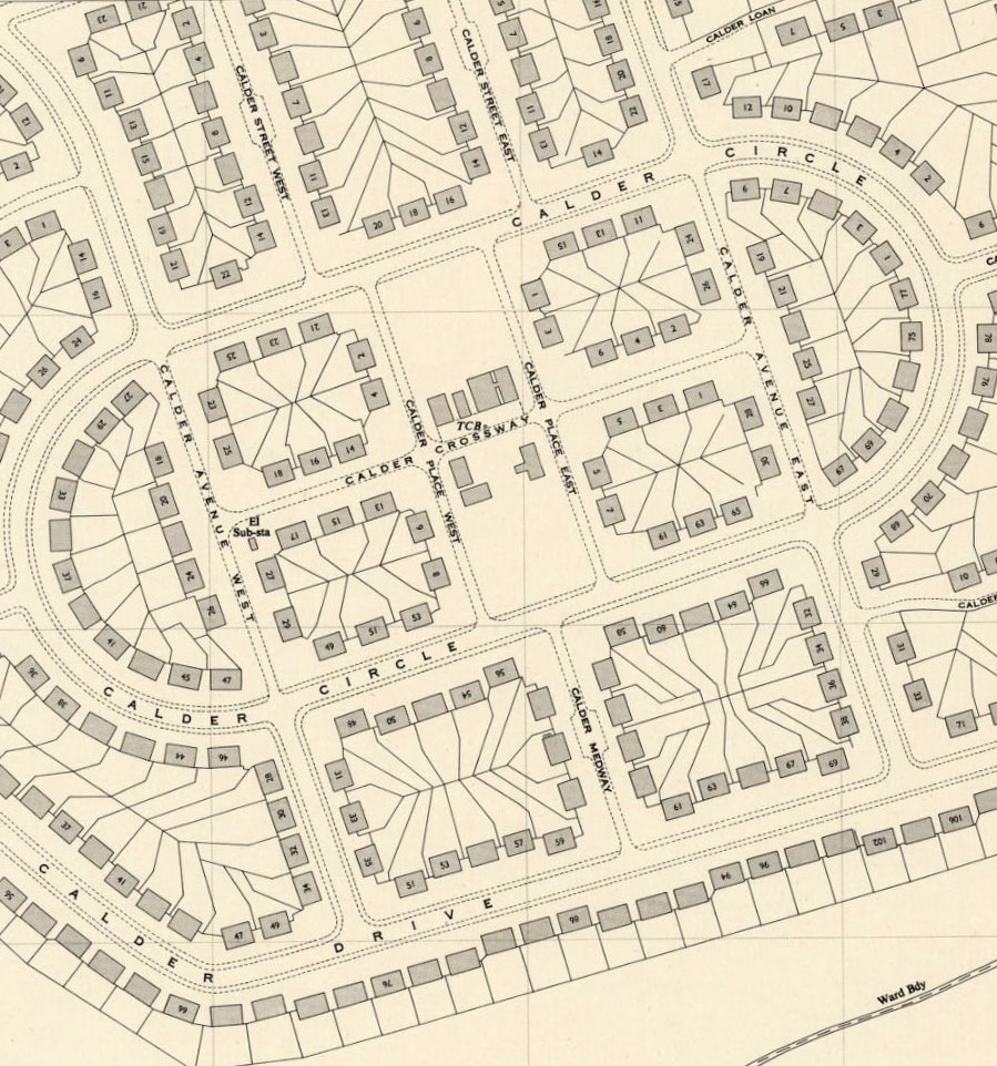
Missing Streets "I'd like to comment on the street names in your table below. There are at least three streets missing from the prefabs column of the table above. The first two are not named on the map above. The third is not shown at all on the map. They are: 1. Calder Place East 2. Calder Place West 3. a small lane with houses on either side that ran between Calder Circle and Calder Drive My address until 1964 (when it was demolished) was “1 Calder Place East”. The streets are not named on the map due presumably to the size of the map." Location of the Missing Streets "Near the bottom of the map, there is a grid of six rectangles within Calder Circle. The middle two of these rectangles were areas of open ground with a swing park in each. The roads running approx. north-south on either side of these swing parks were Calder Place East and Calder Place West. There was also a road running approx west-east that separated the swing parks. It had 5 or 6 shops. The lane that ran from Calder Circle to Calder Drive started in the middle of the southern edge of the southern swing park. I've forgotten the name of that lane, and a lady I know (now aged 90+) who lived there has also forgotten its name." Stewart Fizia: 20 May 2013 |
||||||||||||||||||||||||||||||||||||||||||||
|
Here is the table again, now including Stewart's comments (in green):
Peter Stubbs: 10 August 2017 |
||||||||||||||||||||||||||||||||||||||||||||
|
Comments 3. Stuart Lyon Blackford, Edinburgh |
|
Thank you to Stuart Lyon who wrote: |
|
"This OS Map from 1949/50 shows the Calder area of Edinburgh and includes the streets mentioned by Stewart Fizia above." 1949/50 Map Calder Circle
© Reproduced with acknowledgement to Stuart Lyon Stuart Lyon, Blackford, Edinburgh: 9 August 2017 (3 emails) |
|
Prefab Housing: Background + Recollections |
|
Maps: All Edinburgh Districts: 1870 1915 1925 1940 1955 2001 |
|
|
Map Index: Full Index |
Map Index: Short Index + thumbnails |