|
Edinburgh New Town Greenside |
|
|
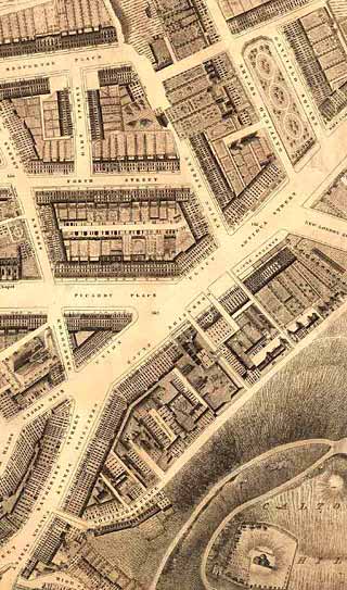
Kirkwood Map - 1819
©
Reproduced
by courtesy of the National Library of Scotland. |
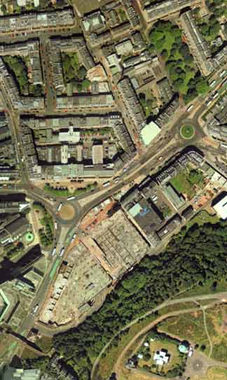
Aerial View - 2001
©
Copyright: XYZ Digital Map Company Limited. |
|
|
|
|
Greenside |
|
|
This is about as far as Edinburgh New Town had extended in 1819. The edges of fields can be seen along the top of the map, and some of the roads in the upper right corner have not yet been named. Many of the buildings are still standing today, including: - CENTRE-LEFT: The Catholic Chapel (now the Cathedral) - TOP LEFT: St Paul's Chapel, York Place - LOWER-CENTRE: The Tabernacle, Greenside Place (church front only) - LOWER RIGHT: The Observatory, Calton Hill Some of the buildings have vanished: - The buildings in Greenside Place have been replaced by a Cinema complex, opened recently after many years' delay. - The small triangle of buildings near the centre of this map have gone and been replaced by a traffic roundabout. - The buildings in the lower-left corner between King Street and Catherine Street have been demolished and replaced by a John Lewis department store, part of the St James Centre shopping complex. The road running diagonally from bottom left to top right is the road from the East End of Princes Street the "Fit o' the Walk" at Leith. It begins as Leith Street, but for most of its length is Leith Walk. with separate names given to individual sections of buildings. |
|
|
Kirkwood Map - 1819 |