|
Edinburgh Transport - Railways Granton Railway 1958 |
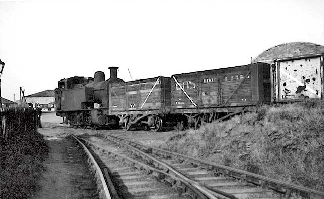
Where in Granton was this photo taken?
© Reproduced with acknowledgement to Alistair McBeath, Granton, Edinburgh Photographer not known
|
Granton Railway |
|
Thank you to Alistair McBeath, Granton, Edinburgh for allowing me to reproduce this photo. Alistair wrote: "This photo was removed from a private photo album. I don't know who took the photo. All I know is the caption on the back of the photo. It reads:, 'Loco 47162, Granton, 4/6/1958'. Someone must recognise the curved structure that appears above the last wagon. Alistair McBeath, Granton, Edinburgh: January 18, 2010. Maybe the engine is reversing along West Harbour Road or West Shore Road, near Granton Harbour." |
|
Question Do you recognise where this photo might have been taken? If so, please email me, Then I'll pass your message on to Alistair McBeath. Thank you. Peter Stubbs: January 21, 2010 |
|
Reply 1. Neil Lawrence Fountainbridge, Edinburgh |
|
Thank you to Neil Lawrence, Edinburgh, for replying: "Here is the location for this picture as far as I can see - judging from the configuration of the railway tracks just before they cross a road. I believe that the photo was taken at the shore end of the Western Breakwater of Granton Harbour. West Harbour Road changes to West Shore Road at just about here. The building with the curved roof is just clipped by the circle on the maps enclosed. It looks like there were a few buildings in the area with curved roofs at that time." Neil Lawrence, Fountainbridge, Edinburgh: January 22, 2010 |
|
Thank you to Neil Lawrence for sending me this extract from an Ordnance Survey map from the early-1950s, from his own collection.
Near the Shore End of Granton Western Breakwater
The railway line leading out of the top of
the map is heading up Granton Western Breakwater. © Reproduced with acknowledgement to Neil Lawrence, Fountainbridge Edinburgh
|
|
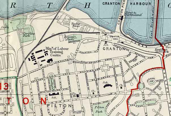
Map 2 Here, we look at an extract from a smaller scale map of 1955. It does not show all the detail of the railway lines in Map 1, but it shows the surrounding area. Granton Harbour, Granton and Pilton
The area covered by Map 1 above lies
immediately below the large letter 'T' © For permission to reproduce please contact peter.stubbs@edinphoto.org.uk Extract from a map by Bartholemew, 1955-56
|
|
Aerial Photo Thank you to Neil Lawrence for also sending me aerial photograph, taken in 1946. However, I don't have copyright permission to add it to the EdinPhoto web site. Peter Stubbs: January 22, 2009 |
|
Reply 2. Walter Lyle Hume Cowes, Isle of Wight, England |
|
Thank you to Walter Lyle Hume who wrote: "Assuming the engine is travelling backwards, it is about to move onto West Harbour Road. The west side of Middle Pier is visible in the background. This line ran just to the west of the Custom House." Cowes, Isle of Wight, England: January 22, 2010 |
|
NOTE The location that identified here is close to the Custom House shown on map 2 above. i.e. about 1/4 mile east of the location given in Reply 1 above. |
|
Reply 3. Walter Lyle Hume Cowes, Isle of Wight, England |
|
After reading Reply 1 above, Walter Lyle Hume replied: |
|
(a) "From Granton Square moving west I can clearly recollect the railway line branching off to the left just beyond the Customs House, this line could be readily seen from West Granton Road." Walter Lyle Hume, Cowes, Isle of Wight, England: January 23, 2010 |
|
Yes. I also remember it well. That's where these photos were taken: Peter Stubbs: January 23, 2009 |
|
(b) "The next short, minor rail siding ran into the Lighthouse Buoy Depot, I do not remember seeing any wagons in the yard but the rails were still in place during my tenure with the Northern Lighthouse Board. Moving further west another single line ran into the then Northern Lighthouse Board's Anthracite Gasworks, where Gas was made for the Lighthouses, Beacons and Buoys and piped direct to the Lighthouse berth at the head of the West Pier from circa 1900 until the 1939-45 war period, when the system changed to using gas cylinders. Again, I never saw this line used." Walter Lyle Hume, Cowes, Isle of Wight, England: January 23, 2010 |
|
(c) "Slightly further west was the line which ran to the Granton Gas Works and Crewe Junction, with a direct line to and from the West Pier. It is on this line, near West Pier, that Neil Lawrence believes that this photo was taken: But if the photo had been taken here, the section of Middle Pier would not have been visible from such an angle. There were numerous sidings, usually full of wagons, and Brechins Shipbreaking Yard between West Pier and Middle Pier." Walter Lyle Hume, Cowes, Isle of Wight, England: January 23, 2010 |
|
I agree that if the buildings in the background were at Middle Pier, then this photo would not have been taken from near West Pier. However is it not possible that the buildings in the background were some of the buildings near West Pier? Peter Stubbs: January 23, 2010 |
|
Reply 4. Douglas Beath Burnie, Tasmania, Australia |
|
Thank you to Douglas Beath who replied: The Hill "Neil Lawrence is right. The train is at the foreshore end of the single track that wound steeply up past Caroline Park House to enter Granton Gas Works, giving the N.B.R. and L.N.E.R. their own access for coal traffic from the east. The line's windeyness was designed to minimise the gradient which was against laden trains, so they were limited to only several wagons at a time, propelled by the loco in the rear. The engine got up a little speed on the foreshore track then, with the crew keeping a sharp lookout for road traffic, it crossed the road where the red-capped shunter too was watching. As the leading wagon passed, the shunter ran alongside and deftly slid his pole over the buffer and under the coupler, then jumped up and sat on it for the trip. At this stage the loco opened up to gain momentum, but soon its chuffs could be heard slowing on the hill. The Foreground Tracks The foreground tracks led to a few short sidings for coal wagons. Immediately west was another level crossing from the foreshore track to a second set of short sidings ending close to Granton Castle gateway. About 1950 the two sets of sidings were merged so the second level crossing and several turnouts were eliminated." The Photo "The photo is presumably of a returning empty train about to cross to the foreshore line. The photo has been carefully retouched round loco chimney & dome and on wagon diagonals which indicate end discharge doors. (I wonder why.) Douglas Beath, Burnie, Tasmania, Australia: January 23, 2010 |
|
Reply 5. Neil Lawrence Fountainbridge, Edinburgh |
|
Neil Lawrence replied (before having had chance to see the confirmation given by Douglas Beath in Reply 4, above): "I still stand by my assumption. If you project the railway line in the middle bottom of the picture, it lines through with a building. © Reproduced with acknowledgement to Neil Lawrence, Fountainbridge Edinburgh I think that is the building shown on the map which looks a bit like a parallelogram and has the number 1639 below it." Neil Lawrence, Fountainbridge, Edinburgh: January 24, 2010 |
|
Thanks, Neil. I agree with your comments. Peter Stubbs, Edinburgh: January 24, 2010 |
|
TRANSPORT |
|||||||
| Full Index |
Bus Tickets |
Railway Tickets |
|||||


