|
1917 |
Leith - 1917
|
|
|
earlier map later map zoom-in zoom-out |
© For permission to reproduce, please contact peter.stubbs@edinphoto.org.uk
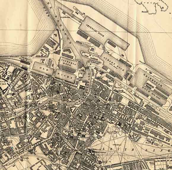
This map by James Bartholemew appeared in the Post Office Directory, 1917-18.
|
Leith - 1917 |
|
Edinburgh Dock has been built on reclaimed land at the eastern end of the docks. The large Imperial Dock has been built to the north. There are now two railway stations at the west of the docks, one in the centre and many railway lines leading directly into the docks from the east. Central Station has been built (bottom centre of map) at the foot of Leith Walk. Almost the whole area of the map, except Leith Links (bottom right) has now been covered by industry and housing. |
|
Questions - Leith Docks |
|
I have been asked: - Where was Queen's Dock? - Where was Newcastle Berth? These locations were mentioned in connection with six Polish torpedo boats that came to Leith in September 1921. |
|
Answers - Leith Docks |
|
Thank you to John D Stevenson Edinburgh, for providing the answers below. John wrote: |
|
Queen's Dock "The west end of the West Old Dock ( nearest the Caledonian Railway Goods Station) near where the two small dry docks were , was used by the Admiralty and was known as "Queens Dock" Even in my time in Henry Robb's shipyard, in 1948-53, it was known as 'The Queens Dock end of the Old Dock !!'." |
|
Newcastle Berth "At that time most Newcastle traffic loaded/discharged at the Shore quay next to what is now Malmaison Hotel (Old Seamen's Home) or the south quay of Edinburgh Dock." |
|
John D Stevenson, March 431, 2006 |
| Leith |
|
Old Maps: 1693 1804 1835 1840 1860 1917 Small Maps: 1870 1915 1925 1940 1955 Large Maps: 1870 1915 1925 1940 1955 Aerial View: 2001 |
|
MAPS: Full index |
|
MAPS: Short Index with thumbnails |