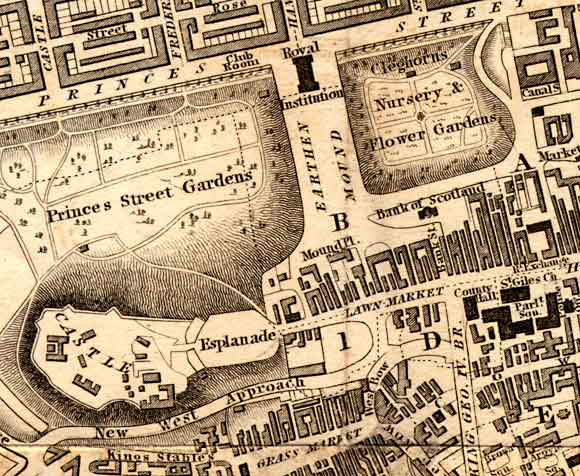
Edinburgh
1840
UPPER
CENTRE: The Royal Institution (now named the Royal Scottish
Academy). Beneath it, to the south is an area described as the Earthen
Mound, but without the detail that appeared in the map of 1830.
UPPER
LEFT and UPPER RIGHT: The gardens to the West and East of
the Earthen Mound have been landscaped. No detail was shown on the
1830 map, but map
above shows the paths that have been created and names the areas as:
-
Princes Street Gardens and
-
Cleghorn's Nursery and Flower Gardens (now East
Princes Street Gardens and the home outdoor skating rink in each
Christmas).
LOWER
LEFT: Edinburgh
Castle - Note that there a New West Approach road has been built
between the castle and the Grassmarket
below it.
LOWER
RIGHT: The western end of the Old Town of Edinburgh.
The Old Town, with its high buildings and narrow
closes extends (off the map to the right) down the High
Street towards Holyrood
Palace and Abbey. Also
in the lower right corner of this map is King George IV bridge, now
known as George IV Bridge. This major road to the south from the top of
the Mound did not feature in the map of 1830. The
West Bow, leading up the hill from the Grassmarket
has, by 1840, been realigned, to lead into King George IV Bridge, rather
than head up the steep hill to join the Lawnmarket at the top of the Royal
Mile as it did ten years earlier. The upper portion of West
Bow is now named Victoria Street. The street, renowned for its
antique shops and other specialist shops. More
pages: National
Galleries
|