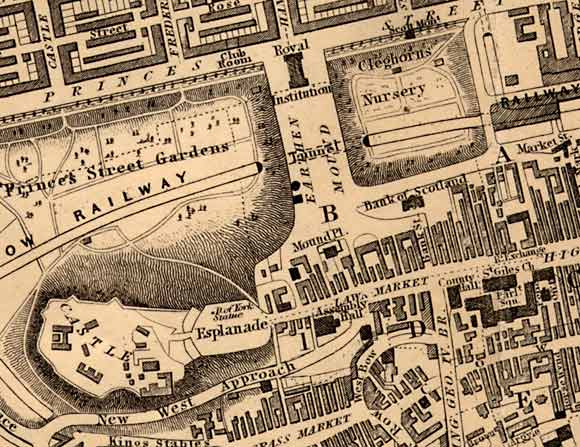
Central Edinburgh

Edinburgh Castle  -  National Galleries  -  St Giles Church

1850

This map, published by WH Lizars, appeared in the Post Office Directory for 1850-51

Central Edinburgh  -  The National Galleries and Edinburgh Castle -  1850 map

earlier map         later map        zoom-in          zoom-out

1830       1840        1850        1860        1870        1917        2001    all (slow)    thumbnails

©  Copyright: For permission to reproduce, please contact peter.stubbs@edinphoto.org.uk


Central Edinburgh  -  Key

Edinburgh Castle  -  National Galleries  -  St Giles Church

NOTE:  This key is based on the 1870 map

YELLOW = Princes St and the Royal Mile

     ORANGE= Hanover St and the Mound

GREEN = National Galleries

BLUE = Edinburgh Castle

RED = St Giles Church

©  Copyright: For permission to reproduce, please contact peter.stubbs@edinphoto.org.uk


Edinburgh

1850

UPPER CENTRE:  The Royal Institution (now named the Royal Scottish Academy).  Beneath it, to the south, is an area described as the Earthen Mound, now with a tunnel for the Edinburgh & Glasgow railway running beneath it.  The National Gallery of Scotland is soon to be built on top of this tunnel.

UPPER LEFT and RIGHT:  The railway runs through the Princes Street Gardens and Cleghorn's Nursery.  At the North side of Cleghorn's Nursery, adjoining Princes Street, the Scott Monument has been built.

LOWER LEFT:  Edinburgh Castle - The road running to the south of Edinburgh Castle is still described as New the West Approach road.

LOWER RIGHT:  The western end of the Old Town of Edinburgh.  The Old Town, with its high buildings and narrow closes extends (off the map to the right) down the High Street towards Holyrood Palace and Abbey.  This part of the map has seen little change since the map of 1830.

More pages:  National Galleries


MAPS:  Full index

Outline Map of the British Isles © MAPS: Short Index with thumbnails


__________________