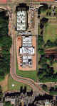
Edinburgh

Central

Edinburgh Castle  -  National Galleries  -  St Giles Church


Edinburgh map  -  1830 ©

1830

Edinburgh map  -  1840 ©

1840

Edinburgh map  -  1850 ©

1850

Edinburgh map  -  1860 ©

1860

Edinburgh map  -  1870 ©

1870

Edinburgh map  -  1917 ©

1917

Edinburgh aerial photo  -  2001  -  zoomed in ©

2001

Edinburgh aerial photo  -  2001  -  zoomed out ©

2001 zoom-out

The Art Galleries and the Offices of The Free Church of Scotland. ©

2001 zoom-in


Key to map of Edinburgh Castle, National Galleries and St Giles Church  -  1870 ©

Key - 1830 to 2001

Maps of Edinburgh Castle, National Galleries and St Giles Church  -  1830 to 2001 ©

All maps - 1830 to 2001


Edinburgh  -  1870  -  Enlargement of part of a map by John Bartholemew that appeared in the Edinburgh & Leith Post Office Directory 1870-71 ©

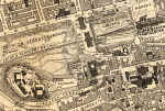
Zoom-out and Enlarge the 1870 Edinburgh Map

PLEASE NOTE:  On the large map, you should be able to read all the street names but:

-  you will need to scroll across and down the map.

-  the map may be very slow to load.
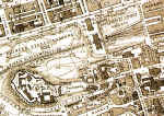
 

Edinburgh

Central

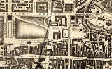
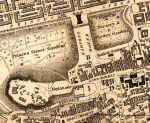
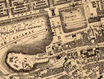
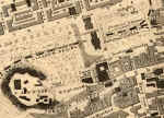
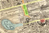
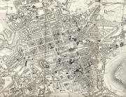
The development of Edinburgh can be traced from these maps.  Click on any map to enlarge it.

-  Early 1700s: Neither the Mound nor the Galleries have yet been built. 

-  1830, 1840:  National Gallery and an Earthen Mound

-  1850:  The railway arrives.

-  1860:  A second National Gallery

-  1870:  More railways and a route up the Mound into George IV Bridge.

-  1917, 2001:  The road lay-out as we know it today.


MAPS:  Full index

Outline Map of the British Isles © MAPS: Short Index with thumbnails


__________________