Edinburgh & Leith


1812

Edinburgh and Leith  -  1812  -  taken from a plan of the roads within and connected to Cramond ©

Road Distances  -  taken from a map of roads within and leading to Cramond District  -  published 1812 ©

Edinburgh & Leith  -  1812

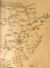
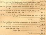
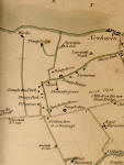
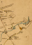
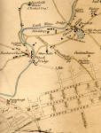
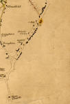
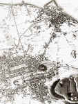
 These extracts are taken from a

 Plan of the roads within and connected with Cramond District, together with a list of the Road Lengths

Edinburgh & Leith  -  zoom-in to top left  -  1812-  © Top left

Edinburgh & Leith  -  zoom-in to top right  -  1812 © Top right

Edinburgh & Leith  - zoom-in to bottom left  -  1812 © Bottom left

Edinburgh & Leith  -  zoom-in to bottom right  -  1812 © Bottom right


1835 to 2001

Map of Edinburgh and Leith  -  1835 ©

1835

Map of Edinburgh and Leith  -  1840 ©

1840

 Map of Edinburgh and Leith  -  1860 ©

1860

  Map of Edinburgh and Leith  -  1870 ©

1870

 Map of Edinburgh and Leith  -  1917 ©

1917

Map of Edinburgh & Leith by John Bartholomew  -  1925 ©

1925

Aerial View of Edinburgh and Leith  -  2001 ©

2001


Edinburgh & Leith

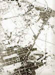
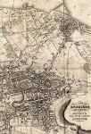
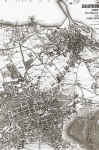
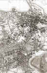
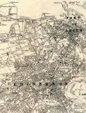
Leith lies on the Firth of Forth, about two miles to the north of Edinburgh.

For many centuries, Leith and Edinburgh were separate boroughs.  Now, Leith together with Portobello, Newhaven, South Queensferry and other towns and villages now forms part of Edinburgh.

Several maps of Edinburgh and Leith appear above.  Please click on any of these maps to see larger images.  It will then be possible to zoom in to either Edinburgh or Leith.


MAPS:  Full index

Outline Map of the British Isles © MAPS: Short Index with thumbnails


__________________